

Transit is the lifeblood of great cities. Without it, those who can’t drive or who can’t afford to drive are cut off from the places where they work, learn, play, and build community. For more than a third of the population, fast, frequent, and reliable transit is a matter of personal freedom. Sadly, today in Austin only a few people have access to homes where they can enjoy that freedom, but AURA is fighting for a vision of the future where all our neighbors can live near good transit. As the City considers major new developments, we want to make sure our newest neighbors live in that future from the start.
On Thursday, July 23rd, Austin City Council will be considering a Tax-Increment Reinvestment Zone (TIRZ) for a proposed development on a 2614-acre, recently-annexed tract on the eastern side of the city called Dog’s Head. Later this year, Council will also be considering amendments to the Austin Strategic Mobility Plan (ASMP) to make changes to the City’s proposed street network in and around this area.
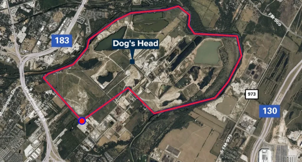
Both of these decisions present valuable opportunities for Austin to lead with transit-supportive, mixed-use, urban development and for us to build something better than the costly, car-centric world we’ve come to expect. We call our proposal for connecting Dog’s Head to the urban core the Dog Door Busway.
According to existing plans, any future residents, customers, or employees traveling to and from Dog’s Head would be forced onto the 12+ lanes of US-183
The current road network proposed by Endeavor, the commercial real estate firm developing Dog’s Head, includes multiple potential crossings of the Colorado River, but does not include any direct connection to Austin’s urban street grid. That means, according to existing plans, any future residents, customers, or employees traveling to and from Dog’s Head would be forced onto the 12+ lanes of US-183—a fact that TXDOT, CAMPO, and CTRMA will no doubt use to justify spending billions of dollars adding even more financially wasteful and environmentally destructive general traffic lanes.
The patchwork of private and public land on the western side of the river, the industrial character of the area, and the massive US-183 interchange all pose a challenge to imagining Dog’s Head as a truly urban place connected to the heart of Austin, where people might be free to choose something other than a car as their primary means of transportation.
But there is another way:
Just across the river from Dog’s Head, a different mixed-use development on the Bolm West tract owned by Kairoi Residential is currently working its first phase through the City’s site plan review process. Based on existing public plans, a small bridge at the eastern end of the tract, where Bolm West touches the decommissioned Govalle Wastewater Plant, offers the best chance for a cost-effective connection between Dog’s Head and the rest of the city. This area lies outside the first phase of Bolm West, making it possible for early public coordination to integrate the bridge into future plans for the site.
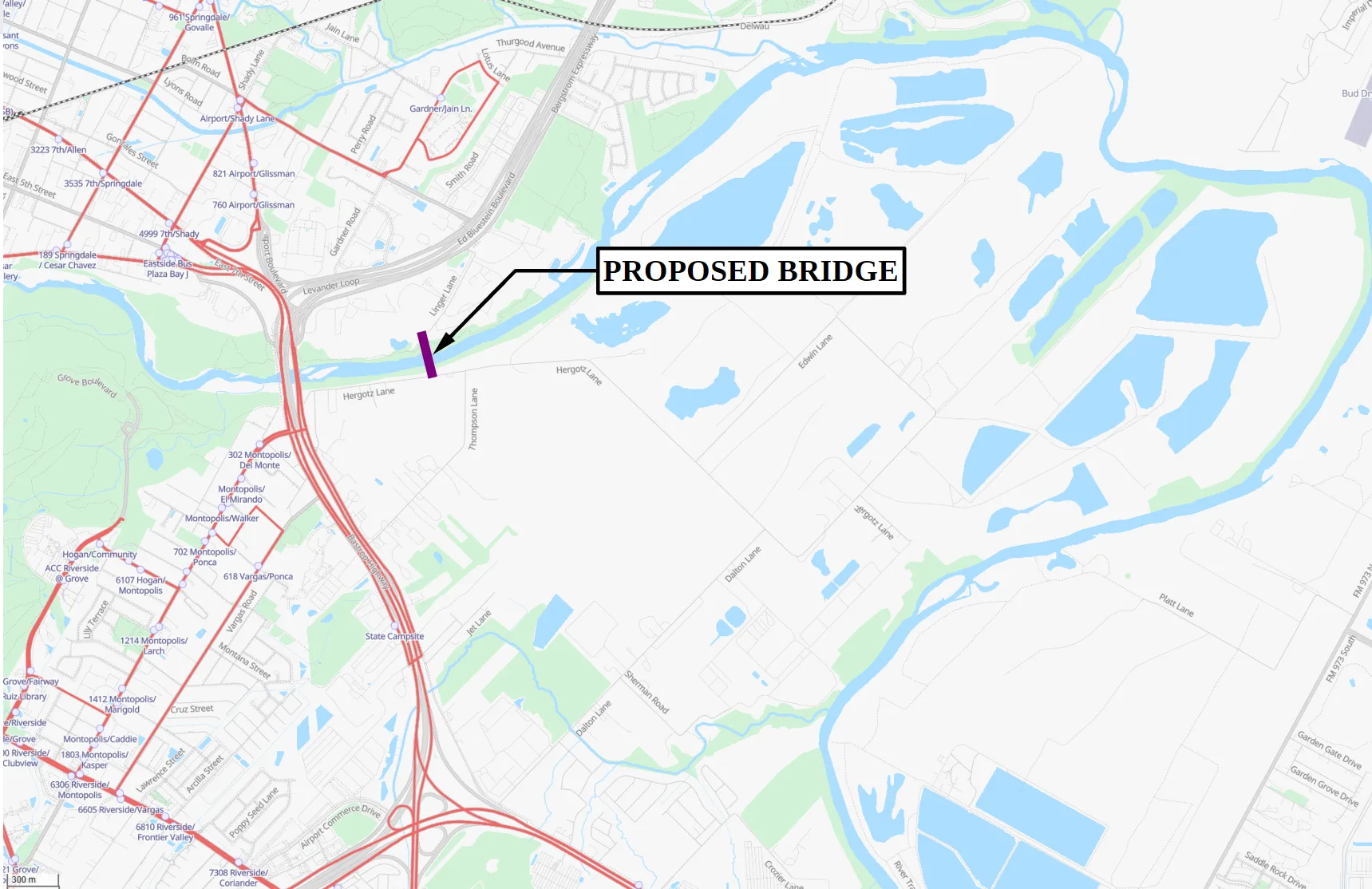
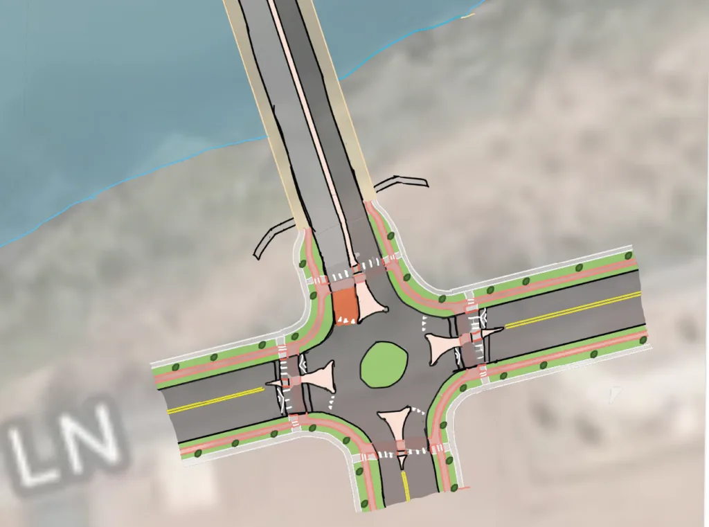
To avoid traffic impacts within the Bolm West development, the new bridge in our proposal would only carry northbound car traffic directly onto the existing public street, Linger Lane, and from there to the northbound 183 frontage road, without ever entering Bolm West. This would allow cars from Dog’s Head driving to destinations north of the central city to avoid congestion at the 183 interchange, without generating disruptive through-traffic on the safe, low-speed streets inside of Bolm West.
More importantly, the new bridge would offer a quick, high-comfort connection for pedestrians and cyclists between Bolm West and Dog’s Head, forming a crucial cross-river link in the future Colorado River Trail planned along the shores of both developments.
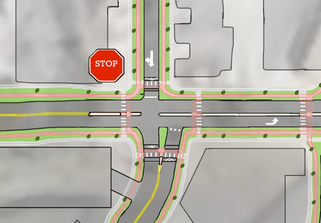
One more ingredient is needed for success, though. For Dog’s Head to ever live up to its promise as a dense, vibrant, and sustainable part of the city, it must be served by frequent and reliable transit. Unfortunately, current plans for the proposed road network make it effectively impossible for CapMetro to ever run time-competitive bus service to Dog’s Head. Any service to downtown using the streets in existing plans would involve (1) running buses through the congested 183 interchange; (2) skipping over potential riders in Bolm West with a mile or more of freeway “dead space” in each direction; (3) adding at least two cycles of signal delay for eastbound buses at the Montopolis intersection; and, (4) navigating a rat’s nest of left turns within Dog’s Head itself. These factors doom transit from the start by slowing down buses, leading to high operating costs, long trip times that can’t compete with cars, and low ridership potential as a result.
Modal filters are a powerful, low-cost tool for making bus trips time-competitive with cars
To solve this problem, our proposal calls for a bus modal filter at the eastern edge of the Bolm West street network, connecting to the new bridge. Common throughout Europe and Asia, bus modal filters are small sections of road that allow buses to pass through, but not cars. As the NYU Marron Institute’s recent Transit Priority Atlas outlines, modal filters are a powerful, low-cost tool for making bus trips time-competitive with cars and increase the total capacity of the city’s street network.
Examples can be found in other American cities like Madison, Wisconsin; but probably the most common type of modal filter in the US is the literal dog door, which allows millions of homes across the country to stay shut without blocking high-priority canine traffic. The Dog Door Busway brings this tried-and-true solution to Austin: buses from Levander Loop — which slips under the 183 interchange — get exclusive access south across the new bridge into Dog’s Head, while buses headed the other way continue straight through Bolm West, right where car traffic is forced north onto Linger Lane.
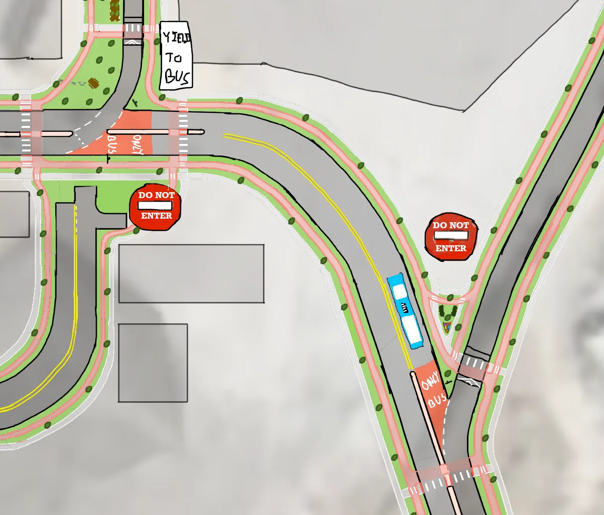
Combined with a few supportive changes to the Dog’s Head internal street plan (not shown in the above PDF) the Dog Door Busway offers a low-cost, adaptable solution for knitting both Bolm West and Dog’s Head into the urban fabric of Austin. In doing so, this solution also lays the groundwork for urban rail to Dog’s Head, by building a bridge connection that can be easily converted to carry a future east-west rail line.
The busway also provides a direct, traffic-free connection for emergency vehicles responding to Dog’s Head
In addition to the advantages offered to bus riders and future residents/commuters, the busway also provides a direct, traffic-free connection for emergency vehicles responding to Dog’s Head during periods of heavy congestion on the 183 interchange. With thoughtful circulation planning, including one-way streets and roundabouts, left-turn conflicts and signal delays can be nearly eliminated for first responders and transit vehicles on both ends of the busway, further cutting trip times.
What does the City need to do?
The Dog’s Head TIRZ will dedicate a share of the development’s future property tax revenue, and potentially new sales tax revenue, to a Tax Increment Fund (TIF) used to pay for public infrastructure. However, what infrastructure gets funded is determined by the TIRZ’s project and financing plan. Council will vote on both the TIRZ’s authorization as well as the TIRZ project and financing plan at the same meeting on Thursday, July 23rd.
AURA urges Austin City Council to amend the TIRZ financing plan to include the Dog Door Busway and its supporting elements.
Later this year, when Council takes up amendments to the Austin Strategic Mobility Plan for the Dog’s Head area, councilmembers should add the Dog Door Busway to those amendments as well, along with explicit language protecting the plan’s transit-only segments.
Two votes, two chances to get this right, and two opportunities to speak up for good transit! Email your councilmember directly and ask them to support the Dog Door Busway. Submit a public comment or sign up to speak before July 23rd, and tell City Council to amend the financing plan. Also, keep an eye out for amendments to the ASMP later this year.